
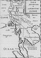
Image: Mekong map in 1715

Size of this preview: 428 × 599 pixels. Other resolutions: 171 × 240 pixels | 500 × 700 pixels.
Original image (500 × 700 pixels, file size: 54 KB, MIME type: image/jpeg)
Description: A map of 1715 by French, incorrectly showing the Chao Praya river as a branch of the Mekong.
Title: Mekong map in 1715
Credit: Scan by User:Markalexander100 of 1715 map in Description de l'univers,
Usage Terms: Public domain
License: Public domain
Attribution Required?: No
Image usage
There are no pages that link to this image.

All content from Kiddle encyclopedia articles (including the article images and facts) can be freely used under Attribution-ShareAlike license, unless stated otherwise.