
Image: Mescal Creek Road, Mount Baden-Powell, and Mountain High Resort

Size of this preview: 337 × 599 pixels. Other resolutions: 135 × 240 pixels | 1,512 × 2,688 pixels.
Original image (1,512 × 2,688 pixels, file size: 1.88 MB, MIME type: image/jpeg)
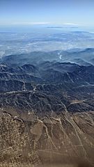
Description: Aerial view from the north of the San Gabriel Mountains showing Mescal Creek Road (right foreground, running to center), Mount Baden-Powell (above center, slightly right of center), and Mountain High Resort (ski area left of center). Behind Mount Baden-Powell, the San Gabriel and Morris reservoirs are visible, then the Los Angeles Basin, and the Palos Verdes peninsula and Santa Catalina Island in the far distance.
Title: Mescal Creek Road, Mount Baden-Powell, and Mountain High Resort
Credit: Own work
Author: Dicklyon
Usage Terms: Creative Commons Attribution-Share Alike 4.0
License: CC BY-SA 4.0
License Link: https://creativecommons.org/licenses/by-sa/4.0
Attribution Required?: Yes
Image usage
The following 2 pages link to this image:

All content from Kiddle encyclopedia articles (including the article images and facts) can be freely used under Attribution-ShareAlike license, unless stated otherwise.