
Image: Mexico 1835-1846 administrative map-en-2

Size of this PNG preview of this SVG file: 654 × 600 pixels. Other resolution: 262 × 240 pixels.
Original image (SVG file, nominally 1,241 × 1,138 pixels, file size: 181 KB)
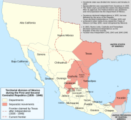
Description: Administrative map of Mexico during the two central republics (1835-1846).
Author: Translated from Mexico_1835-1846_administrative_map-es.svg by User:JWB with minor modifications by User:Spacepotato
Usage Terms: Creative Commons Attribution-Share Alike 3.0
License: CC-BY-SA-3.0
License Link: http://creativecommons.org/licenses/by-sa/3.0/
Attribution Required?: Yes
Image usage
The following 3 pages link to this image:

All content from Kiddle encyclopedia articles (including the article images and facts) can be freely used under Attribution-ShareAlike license, unless stated otherwise.