
Image: Moresnet
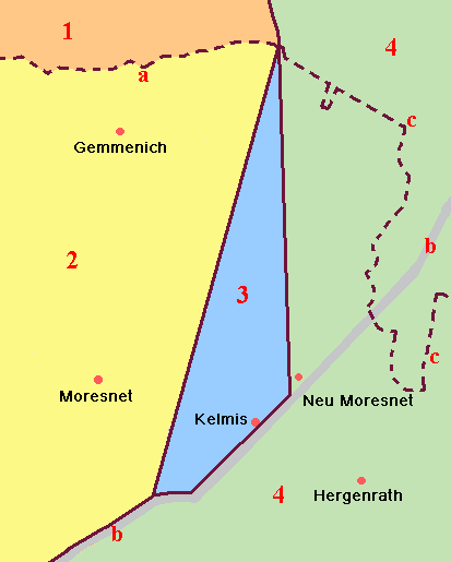
Description: English: Schematic map of the location and surroundings of Neutral Moresnet. Features: 1. The Netherlands (as of 1830)*, province of Limburg 2. Belgium (as of 1830)*, province of Liège 3. Neutral Moresnet (1816–1919) 4. Prussia, Rhine Province a. The Dutch-Belgian border (as of 1843)* b. The Aachen–Liège road c. The present-day German-Belgian border (as of 1919)# (*) Territories (1) and (2) were joined from 1815 until 1830 as the united Kingdom of the Netherlands. In 1830, Belgium seceded, which was acknowledged by the Dutch in 1839. The border between the two countries was formally determined in 1843. (#) In 1919, Belgium received bilingual Moresnet and the part-Germanophone, part-Francophone East Cantons as compensation for damages incurred in World War I. Since then, all territories marked (2), (3) and (4 west of c) have been part of Belgium, except for a brief period in World War II when Germany (re-)annexed Moresnet and the East Cantons. The map was hand-drawn by Arjan de Weerd, who releases it into the public domain, provided he is credited whenever the image is (re)used.
Title: Moresnet
Credit: The map was hand-drawn by Arjan de Weerd, who releases it into the public domain, provided he is credited whenever the image is (re)used. (Moresnet.png)
Author: Arjan de Weerd
Permission: cc-by (From the original statement at the bottom of the English description, it is unclear which version is meant).
Usage Terms: Public domain
License: Public domain
Attribution Required?: No
Image usage
The following 3 pages link to this image:
