
Image: Mweru-Luapula

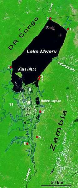
Description: The lower Luapula River, its delta where it enters Lake Mweru, and Mweru's outlet, the Luvua River going on north to the Lualaba and Congo rivers. Water shows up as black in this false-colour NASA satellite image. The extent of the Luapula Swamps is shown by the solid blue line, and the extent of the floodplain is shown as a dotted line. The towns are, in Zambia: 1 Chiengi, 2 Kashikishi, 3 Nchelenge, 4 Mwansabombwe, 5 Mwense; in DR Congo: 6 Pweto, 7 Kilwa, 8 Kasenga. Other features: 9 Chisenga Island, 10 the largest swamp island (in DR Congo), 11 the main floodplain.
Title: Mweru-Luapula
Credit: Image NASA Visible Earth website, overlay in Word
Author: NASA credit Jacques Descloitres, MODIS Rapid Response Team, NASA/GSFC; overlay by User:Rexparry_sydney
Permission: NASA public domain and my permission for overlay to also be Public Domain.
Usage Terms: Public domain
License: Public domain
Attribution Required?: No
Image usage
The following page links to this image:
