
Image: NPS theodore-roosevelt-south-unit-map

Size of this preview: 800 × 543 pixels. Other resolutions: 320 × 217 pixels | 1,237 × 839 pixels.
Original image (1,237 × 839 pixels, file size: 254 KB, MIME type: image/jpeg)
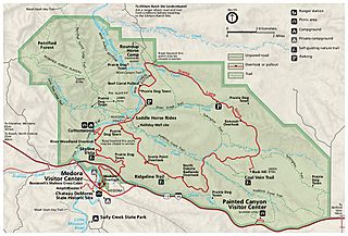
Description: Official map of the south unit of Theodore Roosevelt National Park, featuring the Medora Visitor Center and Painted Canyon area.
Title: NPS theodore-roosevelt-south-unit-map
Credit: U.S. National Park Service (http://npmaps.com/wp-content/uploads/theodore-roosevelt-south-unit-map.jpg)
Author: U.S. National Park Service, restoration/cleanup by Matt Holly
Usage Terms: Public domain
License: Public domain
Attribution Required?: No
Image usage
The following page links to this image:

All content from Kiddle encyclopedia articles (including the article images and facts) can be freely used under Attribution-ShareAlike license, unless stated otherwise.