
Image: Nasa satellite photo side by side 2007-10-22

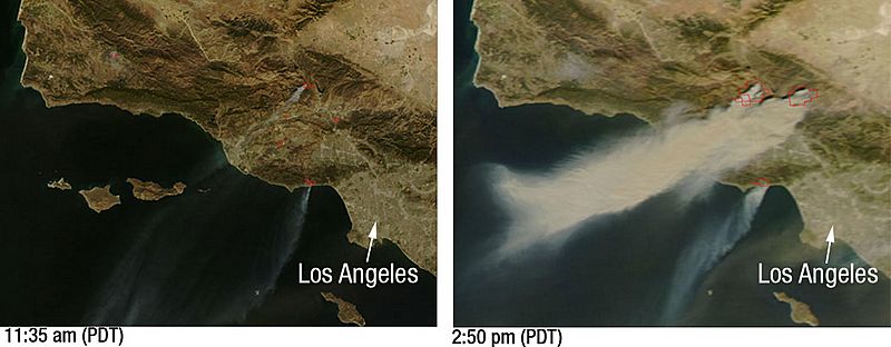
Description: Powerful Santa Ana winds have fueled more than 10 large wildfires throughout Southern California, stretching from Santa Barbara to San Diego. This pair of images, depicting the area around Los Angeles on October 21, 2007, shows just how quickly the fires grew. The left image, captured by NASA’s Terra satellite at 11:35 a.m. local time, shows several fires giving off small plumes of smoke. Just over 3 hours later, at 2:50 p.m. when NASA’s Aqua satellite passed overhead, large amounts of smoke were pouring from blazes northwest of Los Angeles. Actively burning fires are outlined in red. In the right image plumes of smoke can be seen blowing off the coast, indicating the intensity of the winds and the presence of additional fires farther south. According to the National Interagency Fire Center, these blazes have burned over 84,000 acres since they began over the weekend. Thousands of residents have been evacuated from their homes and a state of emergency has been issued for 7 California counties.
Title: Nasa satellite photo side by side 2007-10-22
Credit: Nasa
Author: NASA/MODIS Rapid Response. Story credit: Laura Spector, NASA Goddard Space Flight Center.
Usage Terms: Public domain
License: Public domain
Attribution Required?: No
Image usage
The following 2 pages link to this image:
