
Image: National Grid for Great Britain
No higher resolution available.
National_Grid_for_Great_Britain.png (235 × 434 pixels, file size: 8 KB, MIME type: image/png)
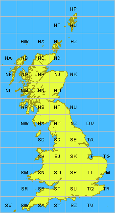
Description: National Grid for Great Britain. Recolored for better separation of sea and lands, and added the missing 'OV' cell number on map, because it actually includes a tiny part of land in the South-West corner.
Title: National Grid for Great Britain
Credit: Ordnance Survey, UK.
Author: Initial graphic made by Keith Edkins, modified by Verdy P. Imported from English Wikipedia.
Usage Terms: Creative Commons Attribution-Share Alike 3.0
License: CC-BY-SA-3.0
License Link: http://creativecommons.org/licenses/by-sa/3.0/
Attribution Required?: Yes
Image usage
There are no pages that link to this image.

All content from Kiddle encyclopedia articles (including the article images and facts) can be freely used under Attribution-ShareAlike license, unless stated otherwise.