
Image: Nebraska Rainwater Basins at Lat. 40.7000, Lon. -98.4722

Size of this preview: 621 × 600 pixels. Other resolutions: 248 × 240 pixels | 886 × 856 pixels.
Original image (886 × 856 pixels, file size: 172 KB, MIME type: image/jpeg)
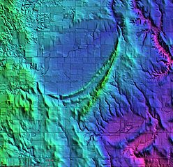
Description: LiDAR image of Nebraska Rainwater Basins at latitude 40.7000 and Longitude -98.4722. The large elliptical basin has a major axis of 6,110 meters and a minor axis of 3,400 meters, which corresponds to a width-to-length ratio of 0.56. The basin is located 600 meters above sea level.
Title: Nebraska Rainwater Basins at Lat. 40.7000, Lon. -98.4722
Credit: Cintos.org
Author: USGS LiDAR image
Usage Terms: Creative Commons Attribution 3.0
License: CC BY 3.0
License Link: https://creativecommons.org/licenses/by/3.0
Attribution Required?: Yes
Image usage
The following page links to this image:

All content from Kiddle encyclopedia articles (including the article images and facts) can be freely used under Attribution-ShareAlike license, unless stated otherwise.