
Image: Norfolk UK local election results 2011 map

Size of this PNG preview of this SVG file: 800 × 497 pixels. Other resolution: 320 × 199 pixels.
Original image (SVG file, nominally 1,425 × 886 pixels, file size: 2.02 MB)
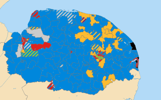
Description: Results of all District, Borough and City Council elections held in May 2011. Colours: Conservative Liberal Democrat Labour Green Independent (politician) UKIP Wards not being contested at these elections Striped wards have mixed representation.
Title: Norfolk UK local election results 2011 map
Credit: Derived from File:Norfolk_UK_electoral_division_map_(blank).svg, created by Nilfanion using Ordnance Survey OpenData.
Author: Woodgreener, derived from work by Nilfanion using Ordnance Survey OpenData
Usage Terms: Creative Commons Attribution-Share Alike 3.0
License: CC BY-SA 3.0
License Link: http://creativecommons.org/licenses/by-sa/3.0
Attribution Required?: Yes
Image usage
There are no pages that link to this image.

All content from Kiddle encyclopedia articles (including the article images and facts) can be freely used under Attribution-ShareAlike license, unless stated otherwise.