
Image: NorthSeaCurrents

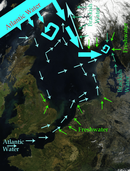
Description: North Sea Map derived from NASA satellite image. This image depicts the currents in the North Sea. The intensive light blue broad arrows show the current and amount of flow from the Atlantic Ocean entering the northern area of the North Sea The smaller pale yellow arrows represent the current from the Atlantic Ocean entering through the English Channel. The bluish green arrows represent brackish water from fjords and the Baltic Sea. The green arrows represent freshwater from various rivers which drain land areas and discharge into the North Sea. Sources used to base this map upon were Safety at Sea currents and North Sea physiography (depth distribution and main currents) Guide to the Oceans By John Pernetta page 184 It would be nice to re-do this map with wiggly flowing arrows for the water currents.
Title: NorthSeaCurrents
Credit: Derivative work from File:NASA NorthSea1 2.jpg
Author: SriMesh, recoloured by Ulamm (talk) 22:29, 27 April 2014 (UTC)
Usage Terms: Creative Commons Attribution-Share Alike 3.0
License: CC BY-SA 3.0
License Link: http://creativecommons.org/licenses/by-sa/3.0
Attribution Required?: Yes
Image usage
The following page links to this image:
