
Image: Northamptonshire UK location map

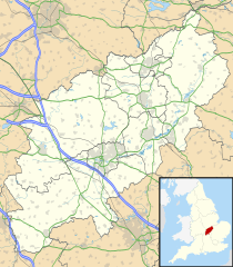
Description: Map of Northamptonshire, UK with the following information shown: Administrative borders Coastline, lakes and rivers Roads and railways Urban areas Equirectangular map projection on WGS 84 datum, with N/S stretched 160% Geographic limits: West: 1.35W East: 0.33W North: 52.67N South: 51.94N
Title: Northamptonshire UK location map
Credit: Ordnance Survey OpenData. Administrative borders and coastline data from Boundary-Line product. All other geographic data from Meridian 2 product. Inset derived from England location map.svg by Spischot.
Author: Nilfanion, created using Ordnance Survey data
Permission: This file is licensed under the Creative Commons Attribution-Share Alike 3.0 Unported license. Attribution: Contains Ordnance Survey data © Crown copyright and database right You are free: to share – to copy, distribute and transmit the work to remix – to adapt the work Under the following conditions: attribution – You must attribute the work in the manner specified by the author or licensor (but not in any way that suggests that they endorse you or your use of the work). share alike – If you alter, transform, or build upon this work, you may distribute the resulting work only under the same or similar license to this one. http://creativecommons.org/licenses/by-sa/3.0 CC BY-SA 3.0 Creative Commons Attribution-Share Alike 3.0 truetrue
Usage Terms: Creative Commons Attribution-Share Alike 3.0
License: CC BY-SA 3.0
License Link: http://creativecommons.org/licenses/by-sa/3.0
Attribution Required?: Yes
Image usage
The following 67 pages link to this image:
- Alderton, Northamptonshire
- All Saints Church, Sutton Bassett
- Althorp
- Apethorpe
- Ashby St Ledgers
- Ashley, Northamptonshire
- Barnwell, Northamptonshire
- Barton Seagrave
- Benefield Castle
- Blisworth
- Brackley
- Burton Latimer
- Canons Ashby (lost settlement)
- Canons Ashby Priory
- Catesby Priory
- Chacombe Priory
- Charwelton BT Tower
- Church Charwelton (lost settlement)
- Clare Street drill hall, Northampton
- Collyweston
- Corby
- Cosgrove, Northamptonshire
- Courteenhall
- Daventry
- Delapré Abbey
- Desborough
- Earls Barton
- East Carlton
- Easton Neston
- Furtho
- Geddington
- Glendon (lost settlement)
- Great Brington
- Harpole Treasure
- Higham Ferrers
- Hollowell
- Holy Cross Church, Daventry
- Irthlingborough
- Kettering
- King's Sutton
- Long Buckby
- Milton Malsor
- Muscott (lost settlement)
- Nether Heyford
- Northampton
- Northampton Castle
- Oundle
- RAF Harrington
- Rainsborough Camp
- Raunds
- Rockingham Forest
- Rothwell, Northamptonshire
- Rushden
- Silverstone
- St Peter and St Paul's Church, Kettering
- Stanwick Lakes
- Stoke Bruerne
- Thorpe Waterville Castle
- Thrapston
- Towcester
- Upper Catesby
- Weedon Lois
- Wellingborough
- West Farndon
- West Hunsbury
- Wythmail
- Template:Location map United Kingdom Northamptonshire
