
Image: Nova totius Terrarum Orbis geographica ac hydrographica tabula (Hendrik Hondius) balanced

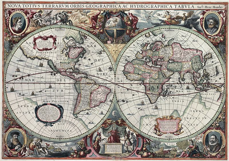
Description: This is an image of Nova totius Terrarum Orbis geographica ac hydrographica tabula, a map of the world created by Hendrik Hondius in 1630, and published the following year in the atlas Atlantis Maioris Appendix. Among its claims to notability is the fact that it was the first dated map published in an atlas, and therefore the first widely available map, to show any part of Australia, the only previous map to do so being Hessel Gerritsz' 1627 Caert van't Landt van d'Eendracht ("Chart of the Land of Eendracht"), which was not widely distributed. The Australian coastline shown is part of the west coast of Cape York Peninsula, discovered by Jan Carstensz in 1623. Curiously, the map does not show the west coast features shown in Gerritsz' Caert.
Title: Latin: Nova Totius Terrarum Orbis Geographica ac Hydrographica Tabula New Geographic and Hydrographic Map of the Whole Worldtitle QS:P1476,la:"Nova Totius Terrarum Orbis Geographica ac Hydrographica Tabula" label QS:Lla,"Nova Totius Terrarum Orbis Geographica ac Hydrographica Tabula" label QS:Len,"New Geographic and Hydrographic Map of the Whole World"
Credit: This is a scan of the copy belonging to the State Library of New South Wales. Access to it is available at http://image.sl.nsw.gov.au/cgi-bin/ebindshow.pl?doc=heritage/a1439;seq=13. The graphical user interface provided does not support downloading the full image at full resolution, but the back end can be cajoled to do so by manually editing the CGI arguments in the url, to http://image.sl.nsw.gov.au/cgi-bin/mrsid/image_jpeg.pl?client=heritage/a1439&image=a128994.sid&x=2624&y=1844&level=0&width=5248&height=3688.
Author: Henricus Hondius II
Usage Terms: Public domain
License: Public domain
Attribution Required?: No
Image usage
The following page links to this image:

_balanced.jpg)