
Image: OV0000 in 1987. Old Descent Route, now defunct. - geograph.org.uk - 1138643
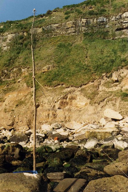
Description: OV0000 in 1987. Old Descent Route, now defunct. This view, taken in July 1987 shows an 8m high Amateur Radio Mast consisting of a tree-trunk bolted via a metal stanchion to a large rock, just inside OV000 square at OV 00011 00017. This position has since been confirmed via GPS averaging but was at the time determined via a mixture of triangulation and linear measurement. The final section of the safeguarded route, built between March & July 1987 can be seen down the lower 45m cliff. The key to this was a 4.3m ladder, purpose built from local materials for direct access into OV0000. This is shown (at top of frame) fixed to the vertical rock-face within SE9999 square and accessible directly from Beast Cliffs Plateau, which in turn was accessible down the upper cliff from the Cleveland Way near War Dike Gate. Foreshore rocks (out of frame) to the left are in TA0099 whilst some pictured on the right are within NZ9900. This route was gradually destroyed without trace over a 3-year period by storms starting 4th March 1999. These caused major rock-falls and though the tidal foreshore in the foreground, remains largely unchanged, the cliff shown here is bare of vegetation, unrecognisable and unstable. A replacement route, 70m NW was opened up on 16th April 2006 but its condition as of January 2009 is unknown. Photo taken 7th July 1987 G4YSS.
Title: OV0000 in 1987. Old Descent Route, now defunct. - geograph.org.uk - 1138643
Credit: From geograph.org.uk
Author: John Earnshaw
Usage Terms: Creative Commons Attribution-Share Alike 2.0
License: CC BY-SA 2.0
License Link: https://creativecommons.org/licenses/by-sa/2.0
Attribution Required?: Yes
Image usage
The following page links to this image:
