
Image: Ogallala changes 1980-1995

Size of this PNG preview of this SVG file: 455 × 599 pixels. Other resolution: 182 × 240 pixels.
Original image (SVG file, nominally 761 × 1,002 pixels, file size: 1.74 MB)
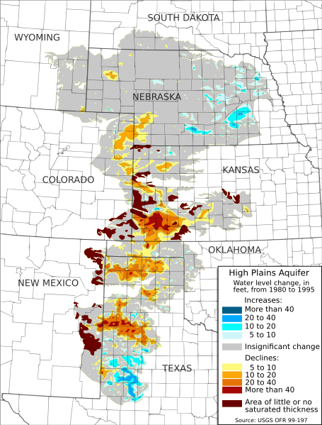
Description: Map of water-level changes in the High Plains/Ogallala Aquifer in parts of Colorado, Kansas, Nebraska, New Mexico, Oklahoma, South Dakota, Texas, and Wyoming, 1980 to 1995. Created from public domain data produced by the USGS and made available in Open-File Report 99-197[1][2]. Authors: Fischer, Brian C.; McGuire, Virginia L.
Author: Kbh3rd
Usage Terms: Creative Commons Attribution-Share Alike 3.0
License: CC-BY-SA-3.0
License Link: http://creativecommons.org/licenses/by-sa/3.0/
Attribution Required?: Yes
Image usage
The following page links to this image:

All content from Kiddle encyclopedia articles (including the article images and facts) can be freely used under Attribution-ShareAlike license, unless stated otherwise.