
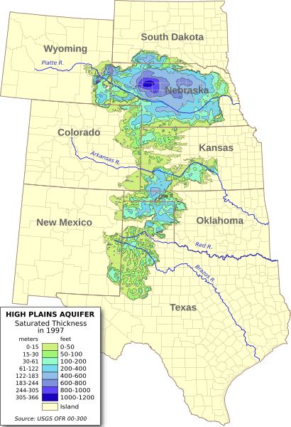
Image: Ogallala saturated thickness 1997-sattk97-v2

Size of this PNG preview of this SVG file: 410 × 600 pixels. Other resolution: 164 × 240 pixels.
Original image (SVG file, nominally 656 × 960 pixels, file size: 1.36 MB)
Description: Digital map of the saturated thickness of the High Plains aquifer in parts of Kansas, Nebraska, New Mexico, Oklahoma, South Dakota, Texas and Wyoming, 1996-97. Produced from GIS data produced by the USGS and published in Open File Report 00-300 (USGS OFR 00-300)[1]. Researchers: Fischer, Brian C.; Kollasch, Keith M.; McGuire, Virginia L.
Author: Kbh3rd
Usage Terms: Creative Commons Attribution-Share Alike 3.0
License: CC-BY-SA-3.0
License Link: http://creativecommons.org/licenses/by-sa/3.0/
Attribution Required?: Yes
Image usage
The following page links to this image:

All content from Kiddle encyclopedia articles (including the article images and facts) can be freely used under Attribution-ShareAlike license, unless stated otherwise.