
Image: PIA16156-Mars Curiosity Rover-Water-AncientStreambed

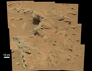
Description: 09.26.2012 Remnants of Ancient Streambed on Mars (Closeup) NASA's Curiosity rover found evidence for an ancient, flowing stream on Mars at a few sites, including the rock outcrop pictured here, which the science team has named "Hottah" after Hottah Lake in Canada's Northwest Territories. It may look like a broken sidewalk, but this geological feature on Mars is actually exposed bedrock made up of smaller fragments cemented together, or what geologists call a sedimentary conglomerate. Scientists theorize that the bedrock was disrupted in the past, giving it the titled angle, most likely via impacts from meteorites. The key evidence for the ancient stream comes from the size and rounded shape of the gravel in and around the bedrock. Hottah has pieces of gravel embedded in it, called clasts, up to a couple inches (few centimeters) in size and located within a matrix of sand-sized material. Some of the clasts are round in shape, leading the science team to conclude they were transported by a vigorous flow of water. The grains are too large to have been moved by wind. Broken surfaces of the outcrop have rounded, gravel clasts, such as the one circled in white, which is about 1.2 inches (3 centimeters) across. Erosion of the outcrop results in gravel clasts that protrude from the outcrop and ultimately fall onto the ground, creating the gravel pile at left. This image mosaic was taken by Curiosity's 100-millimeter Mastcam telephoto lens on its 39th Martian day, or sol, of the mission (Sept. 14, 2012 PDT/Sept. 15 GMT). Polski: Koryta rzeki na Marsie pozostałości z minionych okresów geologicznych Należący do NASA łazik Curiosity znalazł w kilku miejscach, dowody na istnienie w ubiegłych okresach geologicznych, potoków płynących na Marsie, w tym odkrywka skał na zdjęciu, które zespół naukowy nazwał "Hottah" po jeziorze Hottah Lake na Terytorium Północno-Zachodniej Kanady. To może wyglądać jak złamany chodnik, ale ta geologiczny element na Marsie jest faktycznie odkrytym podłożem skalnym, składającym się z mniejszych scementowanych fragmentów, lub jak to geolodzy nazywają konglomeratem osadowym. Naukowcy teoretyzują również, że podłoże skalne zostało uformowane w przeszłości w wyniku procesu nadającego mu kąt nachylenia, najprawdopodobniej za pośrednictwem oddziaływań z meteorytem. Kluczowym dowodem istnienia strumienia jest wielkość i zaokrąglony kształt żwiru wokół podłoża skalnego. Hottah ma kawałki żwiru osadzone w zlepieńcach, konglomeratach, o rozmiarach sięgających do kilku centymetrów, i znajdujących się w macierzystej skale utworzonej z materiału podobnego do piasku. Fakt, że niektóre zlepieńce są okrągłe, doprowadził naukowców do stwierdzenia, że były one transportowane przez energiczny przepływ wody. Ziarna konglomeratów są zbyt duże aby były one przenoszone przez wiatr. Zbliżenie widoku Hottah ujawnia więcej szczegółów odkrywki. Odłamane powierzchnie odkrywki są zbudowane z zaokrąglonych, żwirowych zlepieńców, z takich jak, ten zaznaczony białym kolorem, który ma 3 cm średnicy. Erozja wychodni powoduje, że zlepieńce, które wystają z odkrywki, ostatecznie upadają na podłoże tworząc stertę żwiru. Mozaikę zdjęć podstawowych, z których zostało wykonane zdjęcie finalne, wykonała kamera masztowa łazika Curiosity, uzbrojona w 100-milimetrowy teleobiektyw (ang. Mastcam) w 39 marsjańskim dniu misji łazika Curiosity lub w Sol 39, (na Ziemi był wtedy 14 września 2012 PDT / 15 września GMT) Image Credit: NASA/JPL-Caltech/MSSS
Title: PIA16156-Mars Curiosity Rover-Water-AncientStreambed
Credit: http://photojournal.jpl.nasa.gov/jpeg/PIA16156.jpg
Author: NASA/JPL-Caltech/MSSS
Usage Terms: Public domain
License: Public domain
Attribution Required?: No
Image usage
The following page links to this image:
