
Image: Penang
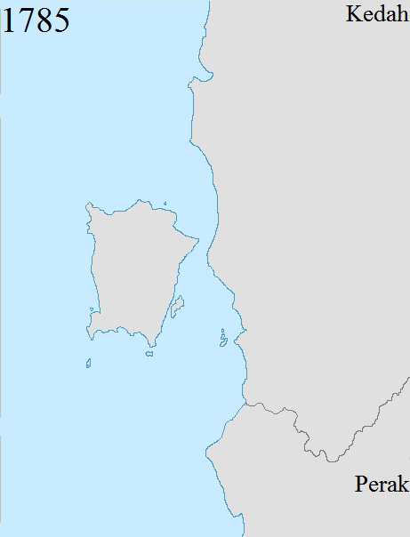
Description: Territorial changes of the former British crown colony of Penang, now a state in Malaysia. Penang's present-day boundaries date back to 1874, when the final change to the boundaries was made following the Pangkor Treaty between the British Empire and Perak. 1786: The British East India Company acquired Penang Island from Kedah.
1800: The British East India Company acquired Province Wellesley from Kedah. At the time, Province Wellesley encompassed a thin strip of land south of the Perai River.
1831: The British East India Company expanded Province Wellesley northwards following a treaty with Siam, which had by then annexed Kedah.[1][2] Province Wellesley now included an area between the Muda River to the north and the Perai River to the south, with the Muda River serving as the boundary between Province Wellesley and Siam.
1859: The British East India Company and Siam signed another treaty to demarcate Province Wellesley's eastern boundaries with Siam.[3] 1874: Province Wellesley was expanded to include the southern watershed of the Kerian River, following the Pangkor Treaty between the British Empire and Perak.[4] Penang's boundaries have remained unchanged since then.
Author: Dreamtrooper
Usage Terms: Creative Commons Attribution-Share Alike 3.0
License: CC-BY-SA-3.0
License Link: http://creativecommons.org/licenses/by-sa/3.0/
Attribution Required?: Yes
Image usage
The following page links to this image:
