
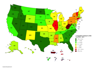
Image: Percent Population change by state and territory from 2010 - 2019

Description: The following is the original description: "A map of Population Change in the United States, by state [and territory], from the 2010 Census to the 2019 American Community Survey Estimates. This map was designed to replace the existing map on the "List of states and territories of the United States by population" Wikipedia Article with as little visual change as possible." Note that the territory population change data (except Puerto Rico) is from the CIA World Factbook.
Title: Percent Population change by state and territory from 2010 - 2019
Credit: https://commons.wikimedia.org/wiki/File:%25_Population_Change_by_state_from_2010_-_2019.png
Author: Originally by User:Pixelsandbacon
Usage Terms: Creative Commons Attribution-Share Alike 4.0
License: CC BY-SA 4.0
License Link: https://creativecommons.org/licenses/by-sa/4.0
Attribution Required?: Yes
Image usage
There are no pages that link to this image.
