
Image: Pisgah Covered Bridge

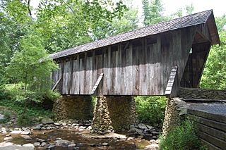
Description: Located on the West Fork Branch of the Little River, within the Uwharrie National Forest, approximately 14 miles southwest of Asheboro, N.C., survives one of the two remaining covered bridges in the entire state of North Carolina. Most unique of all covered bridges in Randolph County, the Pisgah Bridge has survived the ravages of time and history. The 54’ length Pisgah Covered Bridge was built in 1911 <a href="http://www.co.randolph.nc.us/hlpc/downloads/PisgahCoveredBridgeHistory.pdf" rel="nofollow">www.co.randolph.nc.us/hlpc/downloads/PisgahCoveredBridgeH...</a>
Title: Pisgah Covered Bridge
Credit: Flickr: Pisgah Covered Bridge
Author: Donald Lee Pardue
Permission: This image, which was originally posted to Flickr.com, was uploaded to Commons using Flickr upload bot on 20:49, 22 December 2012 (UTC) by Glabb (talk). On that date, it was available under the license indicated. This file is licensed under the Creative Commons Attribution 2.0 Generic license. You are free: to share – to copy, distribute and transmit the work to remix – to adapt the work Under the following conditions: attribution – You must attribute the work in the manner specified by the author or licensor (but not in any way that suggests that they endorse you or your use of the work). http://creativecommons.org/licenses/by/2.0 CC BY 2.0 Creative Commons Attribution 2.0 truetrue
Usage Terms: Creative Commons Attribution 2.0
License: CC BY 2.0
License Link: http://creativecommons.org/licenses/by/2.0
Attribution Required?: Yes
Image usage
The following 5 pages link to this image:
