
Image: Pluto map (Hubble)
No higher resolution available.
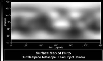
Pluto_map_(Hubble).jpg (350 × 208 pixels, file size: 11 KB, MIME type: image/jpeg)
Description: Map of direct images of Pluto from Hubble. These are among the higher-resolution images of Pluto's high southern latitudes, which were not imaged by New Horizons.
Title: Pluto map (Hubble)
Credit: http://hubblesite.org/newscenter/archive/releases/1996/09/image/c/format/web/ https://hubblesite.org/contents/media/images/1996/09/401-Image.html
Author: Credits: Alan Stern (Southwest Research Institute), Marc Buie (Lowell Observatory), NASA and ESA
Usage Terms: Public domain
License: PD
Attribution Required?: No
Image usage
The following page links to this image:

All content from Kiddle encyclopedia articles (including the article images and facts) can be freely used under Attribution-ShareAlike license, unless stated otherwise.
.jpg)