
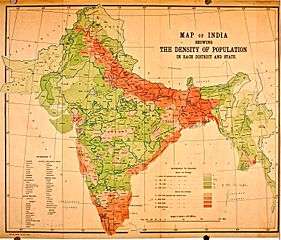
Image: Population density map of British India according to 1911 Census

Size of this preview: 701 × 599 pixels. Other resolutions: 281 × 240 pixels | 2,976 × 2,544 pixels.
Original image (2,976 × 2,544 pixels, file size: 7.09 MB, MIME type: image/jpeg)
Description: Population density map of India in 1911 The color coding is in number of people per square mile (1 sq mile = 2.59 sq kilometers). Image from page 7 of "Census of India, 1911" Publication year:1912 Authors: British India Census Commissioner Publisher: Calcutta : Superintendent government printing, India
Title: Population density map of British India according to 1911 Census
Credit: Image from page 7 of "Census of India, 1911 .." (1912)
Author: Internet Archive Book Images
Usage Terms: Creative Commons Attribution-Share Alike 2.0
License: CC BY-SA 2.0
License Link: https://creativecommons.org/licenses/by-sa/2.0
Attribution Required?: Yes
Image usage
The following page links to this image:

All content from Kiddle encyclopedia articles (including the article images and facts) can be freely used under Attribution-ShareAlike license, unless stated otherwise.