
Image: Portage County school districts overlay
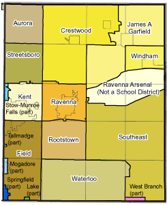
Description: Map of school districts in Portage County with township and municipal boundaries superimposed. Original school district map from state map at the Public Utilities Commission of Ohio website [1] Portage County school district names are outlined in white; district names in all black type are portions of districts from neighboring counties which overflow into Portage County.
Title: Portage County school districts overlay
Credit: Own work
Author: JonRidinger
Permission: This file is licensed under the Creative Commons Attribution 3.0 Unported license. You are free: to share – to copy, distribute and transmit the work to remix – to adapt the work Under the following conditions: attribution – You must attribute the work in the manner specified by the author or licensor (but not in any way that suggests that they endorse you or your use of the work). http://creativecommons.org/licenses/by/3.0 CC BY 3.0 Creative Commons Attribution 3.0 truetrue
Usage Terms: Creative Commons Attribution 3.0
License: CC BY 3.0
License Link: http://creativecommons.org/licenses/by/3.0
Attribution Required?: Yes
Image usage
There are no pages that link to this image.
