
Image: Preserved Counties Wales

Size of this PNG preview of this SVG file: 501 × 599 pixels. Other resolution: 201 × 240 pixels.
Original image (SVG file, nominally 512 × 612 pixels, file size: 159 KB)
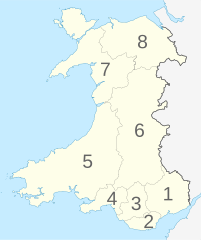
Description: Map of the Preserved Counties of Wales, following the modern definition which follows local authority boundaries. Numbered 1 to 8: 1-Gwent, 2-South Glamorgan, 3-Mid Glamorgan, 4-West Glamorgan, 5-Dyfed, 6-Powys, 7-Gwynedd, 8-Clwyd
Title: Preserved Counties Wales
Credit: This vector image includes elements that have been taken or adapted from this file:
Author: Dank · Jay
Usage Terms: Creative Commons Attribution-Share Alike 4.0
License: CC BY-SA 4.0
License Link: https://creativecommons.org/licenses/by-sa/4.0
Attribution Required?: Yes
Image usage
The following page links to this image:

All content from Kiddle encyclopedia articles (including the article images and facts) can be freely used under Attribution-ShareAlike license, unless stated otherwise.