
Image: Prima Europe tabula

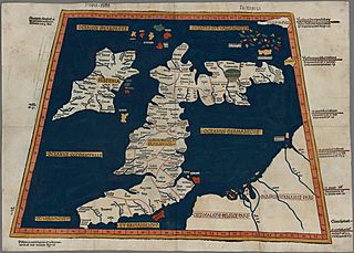
Description: One of the earliest surviving copies of Ptolemy's 2nd century map of the British Isles. Originally published in Ptolemy's Geographia. This is the second issue of the 1482 map, also printed at Ulm, which was the first woodcut map of the British Isles and the first to be printed outside Italy.
Title: Prima Europe tabula
Credit: This image is available from the National Library of Wales You can view this image in its original context on the NLW Catalogue
Author: Ptolemy
Permission: This work is in the public domain in its country of origin and other countries and areas where the copyright term is the author's life plus 100 years or less. This work is in the public domain in the United States because it was published (or registered with the U.S. Copyright Office) before January 1, 1923. This file has been identified as being free of known restrictions under copyright law, including all related and neighboring rights.
Usage Terms: Public domain
License: Public domain
Attribution Required?: No
Image usage
The following 4 pages link to this image:
