
Image: PtolemyWorldMap

Size of this preview: 800 × 547 pixels. Other resolutions: 320 × 219 pixels | 1,500 × 1,026 pixels.
Original image (1,500 × 1,026 pixels, file size: 867 KB, MIME type: image/jpeg)
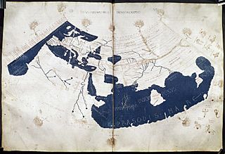
Description: A mid-15th century Florentine map of the world based on Jacobus Angelus's 1406 Latin translation of Maximus Planudes's late-13th century rediscovered Greek manuscripts of Ptolemy's 2nd-century Geography. Ptolemy's 1st (modified conic) projection.
Title: PtolemyWorldMap
Credit: Ptolemy's Geography (Harleian MS 7182, ff 58–59)
Author: Credited to Francesco di Antonio del Chierico
Usage Terms: Public domain
License: Public domain
Attribution Required?: No
Image usage
The following 10 pages link to this image:

All content from Kiddle encyclopedia articles (including the article images and facts) can be freely used under Attribution-ShareAlike license, unless stated otherwise.