
Image: Randstad

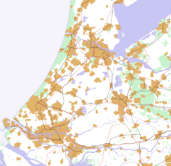
Description: This is a schematic map of the Randstad, Netherlands. A few notes: Orange: Urban areas (schematic) - the urban areas have been a bit overestimated to show the urban areas more clearly. Areas (like parks) in a city are part of the urban area. Some very small villages are not included. Residential areas, industrial and commercial areas are combined. Green: Forests and dunes (schematic)- nearby forests and dunes are combined. Light Blue: Sea (schematic) Middle Blue: Rivers and lakes (schematic) - smaller rivers, lakes and creeks are not included. Red: Highways Black: Railways
Title: Randstad
Credit: Own work
Author: Jeroencommons
Usage Terms: Creative Commons Attribution-Share Alike 3.0
License: CC-BY-SA-3.0
License Link: http://creativecommons.org/licenses/by-sa/3.0/
Attribution Required?: Yes
Image usage
There are no pages that link to this image.
