
Image: Regions of the United States EPA

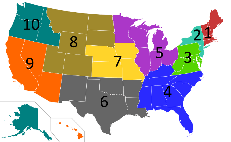
Description: A map of the United States showing the 10 regions of the Environmental Protection Agency. Key: Region 1: Connecticut, Maine, Massachusetts, New Hampshire, Rhode Island, and Vermont. Region 2: New Jersey and New York. (It is also includes Puerto Rico and the U.S. Virgin Islands, which are not shown.) Region 3: Delaware, Maryland, Pennsylvania, Virginia, West Virginia, and the District of Columbia. Region 4: Alabama, Florida, Georgia, Kentucky, Mississippi, North Carolina, South Carolina, and Tennessee. Region 5: Illinois, Indiana, Michigan, Minnesota, Ohio, and Wisconsin. Region 6: Arkansas, Louisiana, New Mexico, Oklahoma, and Texas. Region 7: Iowa, Kansas, Missouri, and Nebraska. Region 8: Colorado, Montana, North Dakota, South Dakota, Utah, and Wyoming. Region 9: Arizona, California, Hawaii, and Nevada. (It also includes Guam and American Samoa, which are not shown.) Region 10: Alaska, Idaho, Oregon, and Washington.
Title: Regions of the United States EPA
Credit: Blank_US_Map.svg
Author: Blank_US_Map.svg: User:Theshibboleth derivative work: Ninjatacoshell (talk)
Usage Terms: Creative Commons Attribution-Share Alike 3.0
License: CC-BY-SA-3.0
License Link: http://creativecommons.org/licenses/by-sa/3.0/
Attribution Required?: Yes
Image usage
The following page links to this image:
