
Image: SAR-Mainstem-Map med
No higher resolution available.
SAR-Mainstem-Map_med.jpg (450 × 347 pixels, file size: 48 KB, MIME type: image/jpeg)
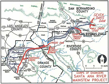
Description: Map of the 100-year floodplain of the Santa Ana river with flood control structures labelled
Title: SAR-Mainstem-Map med
Credit: http://www.ocflood.com/SARP.aspx
Author: U.S. Army Corps of Engineers
Usage Terms: Public domain
License: Public domain
Attribution Required?: No
Image usage
The following 2 pages link to this image:

All content from Kiddle encyclopedia articles (including the article images and facts) can be freely used under Attribution-ShareAlike license, unless stated otherwise.