
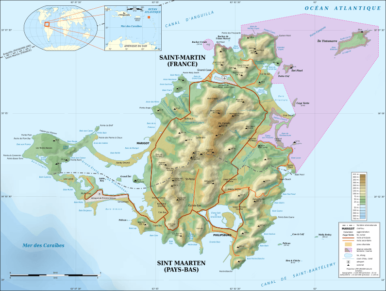
Image: Saint-Martin Island topographic map-fr

Description: Topographic map in French of the Caribbean island of Saint-Martin / Sint Maarten, divided between French and Dutch halves. Note: the shaded relief is a raster image embedded in the SVG file.
Title: Saint-Martin Island topographic map-fr
Credit: Own work References used: Landsat ETM+ imagery Astronaut photograph from the Image Science & Analysis Laboratory, NASA Johnson Space Center : ISS004-E-8155 image (orthorectified) NASA SRTM1v3 and SRTM30 Plus data Additional reference for the toponymy: Géoportail France Reference for the nature reserve limits: Legifrance
Author: Eric Gaba (Sting - fr:Sting)
Permission: Attribution and Share-Alike required Any use of this map can be made as long as you credit me (Eric Gaba – Wikimedia Commons user: Sting) as the author and distribute the copies and derivative works under the same license(s) that the one(s) stated below. A message with a reply address would also be greatly appreciated.
Usage Terms: Creative Commons Attribution-Share Alike 3.0
License: CC BY-SA 3.0
License Link: http://creativecommons.org/licenses/by-sa/3.0
Attribution Required?: Yes
Image usage
The following page links to this image:
