
Image: Samoa geologic map

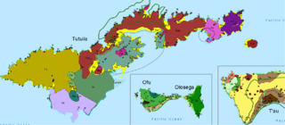
Description: Samoa geologic map, where Volcanic Series are labeled as: Po for Taputapu, Rll and Rlt for Leone (Rla is an ash cone and Rlc is a cinder cone), Pa for Alofau, Pol for Olomoana, Ppe for Pago, and Ppi for Pago Intra-Caldera. Pt are trachyte plugs and dikes, such as Matafao, Vatia, and Pioa ("the rainmaker"). Ra depicts beach sand and alluvium, while the green line is the national park boundary, and the dashed line is the boundary of the caldera.
Title: Samoa geologic map
Credit: National Park of American Samoa, Geologic Resource Evaluation Report, Natural Resource Report NPS/NRPC/GRD/NRR - 2008/25
Author: National Park Service, US Dept. of the Interior
Usage Terms: Public domain
License: Public domain
Attribution Required?: No
Image usage
The following page links to this image:
