
Image: Santa Clara County highway map, 1920s

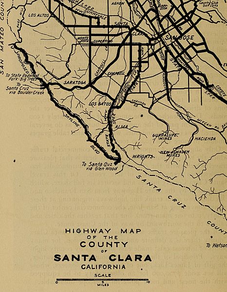
Description: Highway Map of the County of Santa Clara, California; see full image below Identifier: californiahighwa00blow (find matches) Title: California highways; a descriptive record of road development by the state and by such counties as have paved highways Year: 1920 (1920s) Authors: Blow, Ben, 1868- Subjects: Roads Publisher: San Francisco Contributing Library: The Library of Congress Digitizing Sponsor: The Library of Congress View Book Page: Book Viewer About This Book: Catalog Entry View All Images: All Images From Book Click here to view book online to see this illustration in context in a browseable online version of this book. Text Appearing Before Image: rafficwhich the roads of Santa Clara County bear is that pleasuretravel which, with the cheapening of the automobile, hasincreased so tremendously of late years. Of this travelSanta Clara County invites and secures its full share, whichis poured in by the State Highway from San Francisco andOakland, two main trunk line highways originating at thesepoints converging at San Jose, the commercial center of thecounty, into one main trunk line that reaches the cities andvalleys to the southward by way of the Coast route. Of the pleasure traffic which passes through Santa ClaraCounty there is a definite and natural diversion, for manypoints of interest exist made easy of access by county high-ways. Principal of these is the famous Lick Observatory,the gift of James Lick, one of Californias pioneers, whosewill set aside $700,000 for an observatory to be equippedwith the finest and most powerful telescope obtainable. (241) To San MateoSan Francisco SAN FRANCISCO BAY To Nilgy Hayward, tfi. mmm. Text Appearing After Image: To Santa Quz ▼ V-^via Glen Mod I v-.^- HIGHWAY MAP OF THE COUNTY SANTA CLARA CALIFORNIA SCALE O 5 10MILES With the exception of the Sky-line Boulevard and the Pacheco Pass route of the State High-way all highways shown are completed. ALAMEDA COUNTS (243) Note About Images Please note that these images are extracted from scanned page images that may have been digitally enhanced for readability - coloration and appearance of these illustrations may not perfectly resemble the original work.
Title: Santa Clara County highway map, 1920s
Credit: https://www.flickr.com/photos/internetarchivebookimages/14779348344/ Source book page: https://archive.org/stream/californiahighwa00blow/californiahighwa00blow#page/n425/mode/1up
Author: Internet Archive Book Images
Permission: At the time of upload, the image license was automatically confirmed using the Flickr API. For more information see Flickr API detail.
Usage Terms: No known copyright restrictions
License: No restrictions
License Link: https://www.flickr.com/commons/usage/
Attribution Required?: No
Image usage
The following page links to this image:
