
Image: Santorini2022OSM

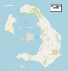
Description: This map of Santorini and nearby islands shows the islands' towns, villages and some other geographical details, and is likely the most comprehensive map of the islands in this respect that you'll find anywhere online. It has been stitched together from panels of Open Street Map (which is freely licensed to all) with details plotted by the uploader, including transliterations of the towns' and villages' names, which were in Greek only at the source.
Title: Santorini2022OSM
Credit: Own work
Author: Kelisi
Permission: The aforesaid website is freely usable to all.
Usage Terms: Creative Commons Attribution-Share Alike 4.0
License: CC BY-SA 4.0
License Link: https://creativecommons.org/licenses/by-sa/4.0
Attribution Required?: Yes
Image usage
The following page links to this image:
