
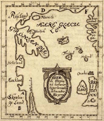
Image: Skálholt-Karte
No higher resolution available.
Skálholt-Karte.png (341 × 398 pixels, file size: 290 KB, MIME type: image/png)
Description: The Skálholt-map made by the icelandic teacher Sigurd Stefansson in the year 1570. Description Greenlands from Bjørn Jonsen of Skarsaa in Iceland from the year 1669, latin by Theodor Thorlac. Note: Helleland ('Stone Land'=Baffin island) Markland ('forest land'=Labrador) Skrælinge Land ('land of the savages'=Labrador) Promontorium Vinlandiæ (the of Vinland=Newfoundland)
Title: Skálholt-Karte
Credit: Sigurd Stefánsson - Beschreibung Grönlands und die Skálholt-Karte
Author: Sigurd Stefánsson - Copy by Jörg Schulz
Usage Terms: Public domain
License: Public domain
Attribution Required?: No
Image usage
The following 7 pages link to this image:

All content from Kiddle encyclopedia articles (including the article images and facts) can be freely used under Attribution-ShareAlike license, unless stated otherwise.