
Image: StHelens1818GreenwoodsMap
No higher resolution available.
StHelens1818GreenwoodsMap.png (368 × 271 pixels, file size: 246 KB, MIME type: image/png)
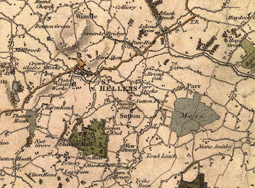
Description: A crop of C. & J. Greenwood's, Map of the County Palatine of Lancaster, from an Actual Survey made in the Year 1818. First edition, 1830.
Title: StHelens1818GreenwoodsMap
Credit: Taken direct from source
Usage Terms: Fair use of copyrighted material in the context of St Helens, Merseyside
License: Fair use
License Link: //en.wikipedia.org/wiki/File:StHelens1818GreenwoodsMap.png
Image usage
The following page links to this image:

All content from Kiddle encyclopedia articles (including the article images and facts) can be freely used under Attribution-ShareAlike license, unless stated otherwise.