
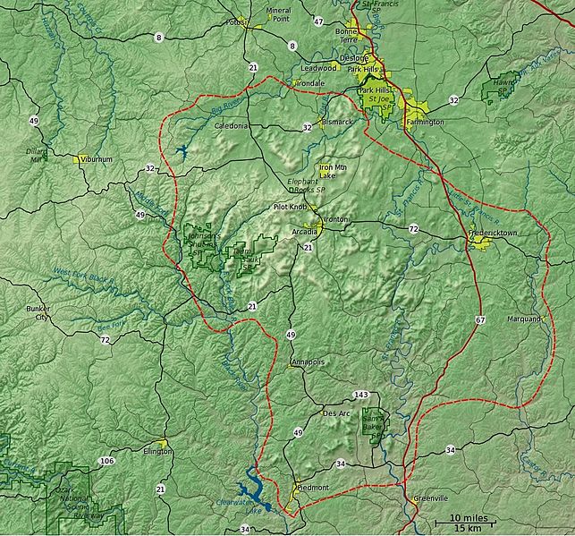
Image: St Francois Mtns relief detail v1

Description: Detailed shaded relief map of the St. Francois Mountains. The red dashed line delineates the St. Francois Mountain physiographic region as delineated in "Landforms of Missouri", Walter A. Schroeder, 1990. Metadata for the GIS data file: Title of Content: Landforms of Missouri Content Publisher: University of Missouri Publication Place: Columbia, Missouri Publication Date: 1990 Content Summary: Geo-dataset delineating the landforms of Missouri. Content Purpose: Generally used in the physical and natural sciences for spatial analysis. Supplemental Information: Procedures_Used: Manually drawn by Walter A. Schroeder in 1990. Digitization at the Missouri Dept. of Conservation. Edited and corrected at the Geographic Resources Center. Revisions: Revised by James D. Harlan, August 2000. Reviews_Applied_to_Data: Reviewed by James D. Harlan, August 2000. Related_Spatial_and_Tabular_Data_Sets: none Other_References_Cited: Walter A. Schroeder Notes: none st_lndfm.e00.gz
Title: St Francois Mtns relief detail v1
Credit: Own work
Author: Kbh3rd
Usage Terms: Creative Commons Attribution-Share Alike 3.0
License: CC BY-SA 3.0
License Link: https://creativecommons.org/licenses/by-sa/3.0
Attribution Required?: Yes
Image usage
The following page links to this image:
