
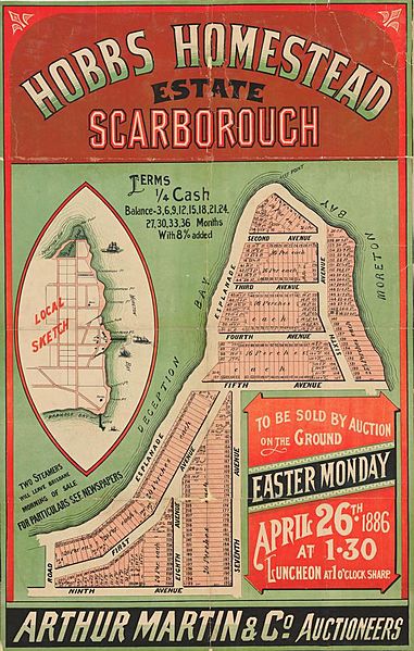
Image: StateLibQld 2 262956 Estate map of Hobbs Homestead Estate, Scarborough, Queensland, 1886

Size of this preview: 381 × 599 pixels. Other resolutions: 152 × 240 pixels | 636 × 1,000 pixels.
Original image (636 × 1,000 pixels, file size: 151 KB, MIME type: image/jpeg)
Description: Estate map of Hobbs Homestead Estate, Scarborough, Queensland, 1886 Estate map showing allotments to be sold on the 26th March 1886 by Arthur Martin & Co., Auctioneers. The plan includes a local sketch. The allotments covered the area adjacent to the Esplanade, Ninth Avenue, Seventh Avenue, Sixth Avenue and Fifth Avenue, Scarborough.
Title: StateLibQld 2 262956 Estate map of Hobbs Homestead Estate, Scarborough, Queensland, 1886
Credit: Item is held by John Oxley Library, State Library of Queensland.
Usage Terms: Public domain
License: Public domain
Attribution Required?: No
Image usage
The following page links to this image:

All content from Kiddle encyclopedia articles (including the article images and facts) can be freely used under Attribution-ShareAlike license, unless stated otherwise.