
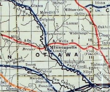
Image: Stouffer's Railroad Map of Kansas 1915-1918 Ottawa County
No higher resolution available.
Stouffer's_Railroad_Map_of_Kansas_1915-1918_Ottawa_County.png (355 × 298 pixels, file size: 213 KB, MIME type: image/png)
Description: Stouffer's Railroad Map of Kansas, 1915-1918, Ottawa County.
Title: Stouffer's Railroad Map of Kansas 1915-1918 Ottawa County
Credit: http://www.kansasmemory.org/item/227380 (Kansas Historical Society)
Author: J.W. Stouffer, download / crop / cleanup from larger map by Steve Meirowsky
Usage Terms: Public domain
License: Public domain
Attribution Required?: No
Image usage
The following page links to this image:

All content from Kiddle encyclopedia articles (including the article images and facts) can be freely used under Attribution-ShareAlike license, unless stated otherwise.