
Image: Sultanate of Bengal
No higher resolution available.
Sultanate_of_Bengal.png (327 × 246 pixels, file size: 19 KB, MIME type: image/png)
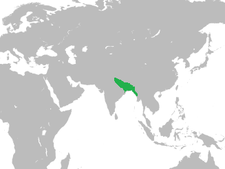
Description: Map of the Sultanate of Bengal in Asia
Title: Sultanate of Bengal
Credit: At its greatest extent, the Bengal Sultanate's realm and protectorates stretched from Jaunpur in North India in the west to Tripura and Arakan in the east Source: Page 16, Perween Hasan (15 August 2007). Sultans and Mosques: The Early Muslim Architecture of Bangladesh. I.B.Tauris. ISBN 978-1-84511-381-0. World Map used: https://commons.wikimedia.org/wiki/File:BlankMap-World-noborders.png
Author: HistoryofBangladesh
Usage Terms: Creative Commons Attribution-Share Alike 4.0
License: CC BY-SA 4.0
License Link: http://creativecommons.org/licenses/by-sa/4.0
Attribution Required?: Yes
Image usage
The following page links to this image:

All content from Kiddle encyclopedia articles (including the article images and facts) can be freely used under Attribution-ShareAlike license, unless stated otherwise.