
Image: Tali-coste-chiaha-chiaves-sp1
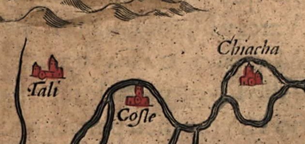
Description: Detail of the Native American villages of Chiaha (spelled "Chiacha" on the map), Coste, and Tali in what is now East Tennessee, in the southeastern United States, on a 1584 map of La Florida. The map was drawn by Spanish royal cartographer Geronimo Chiaves, and was probably based on accounts by members of the Hernando de Soto expedition (1539-1543). The map was originally published in Abraham Ortelius' Theatrum Orbis Terrarum in 1584. Chiaha is believed to have been located on what was later called Zimmerman's Island (now submerged) near modern Douglas Dam. Coste is believed to have been located on Bussell Island, at the mouth of the Little Tennessee River.
Title: Tali-coste-chiaha-chiaves-sp1
Credit: https://www.loc.gov/exhibits/earlyamericas/online/aftermath/aftermath2.html
Author: Geronimo Chiaves, Abraham Ortelius
Usage Terms: Public domain
License: Public domain
Attribution Required?: No
Image usage
The following 2 pages link to this image:
