
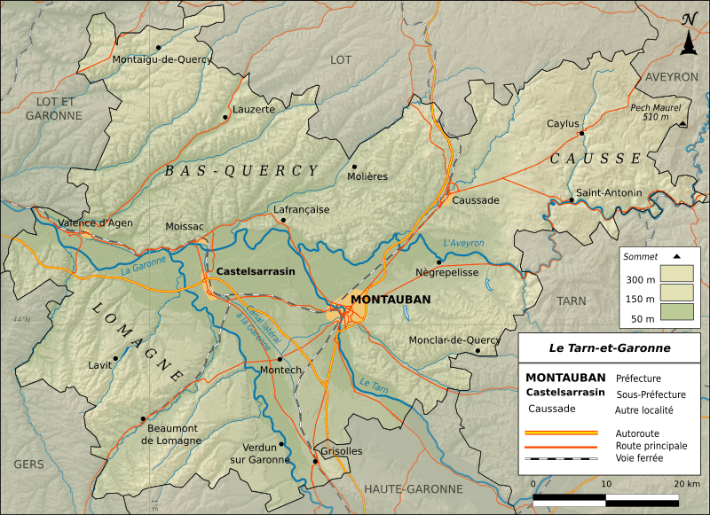
Image: Tarn-et-Garonne-routes

Size of this PNG preview of this SVG file: 800 × 581 pixels. Other resolution: 320 × 232 pixels.
Original image (SVG file, nominally 1,016 × 738 pixels, file size: 4.08 MB)
Description: Carte topographique du Tarn-et-Garonne N: 44.399 S: 44.765 E: 2.002 O: 0.733 Projection : IGN-GEOPORTALFXX (équirectangulaire) Relief : SRTM3v2 Hydrographie : SIE Bassin Adour Garonne (mentions légales) Routes et Voies ferrées : IGN-ROUTE 500® Limites départementales : IGN-GEOFLA® Carte crée avec Qgis et Inkscape.
Title: Tarn-et-Garonne-routes
Credit: Own work
Author: Boldair
Usage Terms: Creative Commons Attribution-Share Alike 3.0
License: CC BY-SA 3.0
License Link: http://creativecommons.org/licenses/by-sa/3.0
Attribution Required?: Yes
Image usage
The following page links to this image:

All content from Kiddle encyclopedia articles (including the article images and facts) can be freely used under Attribution-ShareAlike license, unless stated otherwise.