
Image: Tassili n’Ajjer National Park NASA Landsat 7 (2000)
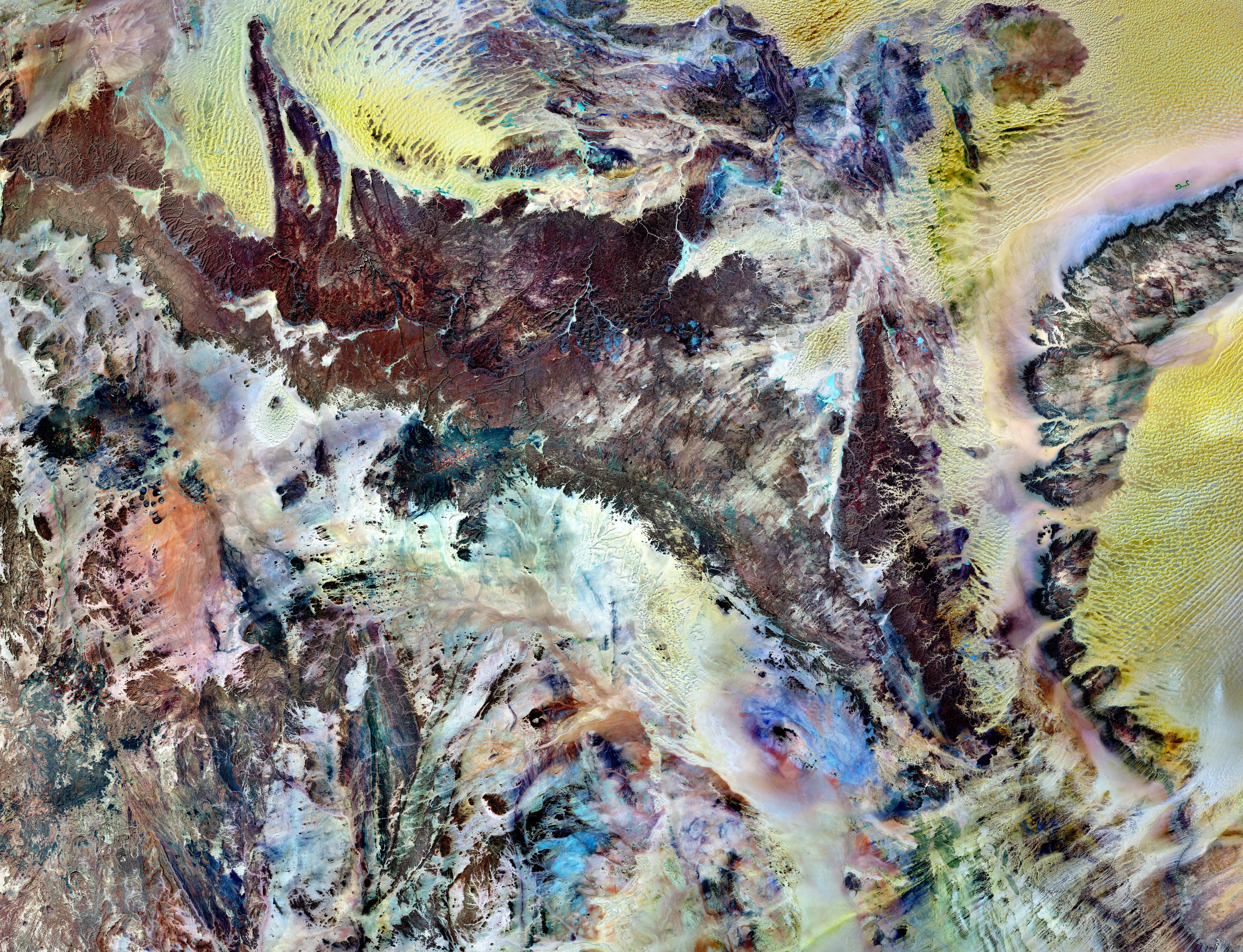
Description: Tassili n’Ajjer National Park covers 72,000 square kilometers (27,800 square miles) in southeastern Algeria. Part of the Sahara Desert, the park has a bone-dry climate with scant rainfall, yet does not blend in with Saharan dunes. Instead, the rocky plateau rises above the surrounding sand seas. Rich in geologic and human history, Tassili n’Ajjer is a United Nations Educational, Scientific and Cultural Organization (UNESCO) World Heritage Site. This image is made from multiple observations by the Landsat 7 satellite in the year 2000. It uses a combination of infrared, near-infrared, and visible light to better distinguish between the park’s various rock types. Sand appears in shades of yellow and tan. Granite rocks appear brick red. Blue areas are likely salts. As the patchwork of colors suggests, the geology of Tassili n’Ajjer is complex. The plateau is composed of sandstone around a mass of granite dating from the Precambrian. Over billions of years, alternating wet and dry climates have shaped these rocks in multiple ways. Deep ravines are cut into cliff faces along the plateau’s northern margin. The ravines are remnants of ancient rivers that once flowed off the plateau into nearby lakes. Where those lakes once rippled, winds now sculpt the dunes of giant sand seas. In drier periods, winds eroded the sandstones of the plateau into “stone forests,” and natural arches. Not surprisingly, the park’s name means “plateau of chasms.” Humans have also modified the park’s rocks. Some 15,000 engravings have so far been identified in Tassili n’Ajjer. From about 10,000 B.C. to the first few centuries A.D., successive populations also left the remains of homes and burial mounds. References Landsat Program. (2011, February 22). Tassili n’Ajjer National Park. Accessed February 28, 2011. World Heritage. (2011). Tassili n’Ajjer. UNESCO. Accessed February 28, 2011.
Title: Tassili n’Ajjer National Park NASA Landsat 7 (2000)
Credit: NASA Earth Observation Image of the Day, 27 March 2011
Author: NASA Landsat 7 image by Michael Taylor, Landsat Science Project Office. Caption by Michon Scott based on image interpretation by Michael Taylor.
Permission: This file is in the public domain in the United States because it was solely created by NASA. NASA copyright policy states that "NASA material is not protected by copyright unless noted". (See Template:PD-USGov, NASA copyright policy page or JPL Image Use Policy.) Warnings: Use of NASA logos, insignia and emblems is restricted per U.S. law 14 CFR 1221. The NASA website hosts a large number of images from the Soviet/Russian space agency, and other non-American space agencies. These are not necessarily in the public domain. Materials based on Hubble Space Telescope data may be copyrighted if they are not explicitly produced by the STScI.[1] See also Template:PD-Hubble and Template:Cc-Hubble. The SOHO (ESA & NASA) joint project implies that all materials created by its probe are copyrighted and require permission for commercial non-educational use. [2] Images featured on the Astronomy Picture of the Day (APOD) web site may be copyrighted. [3] The National Space Science Data Center (NSSDC) site has been known to host copyrighted content even though its photo gallery FAQ states that all of the images in the photo gallery are in the public domain. (On Flickr: http://www.flickr.com/photos/gsfc/5565307398/ under CC-BY-2.0)
Usage Terms: Public domain
License: Public domain
Attribution Required?: No
Image usage
The following page links to this image:

.jpg)