
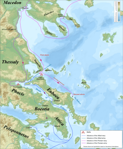
Image: Thermopylae & Artemisium campaign map

Size of this preview: 493 × 600 pixels. Other resolutions: 197 × 240 pixels | 822 × 1,000 pixels.
Original image (822 × 1,000 pixels, file size: 1.04 MB, MIME type: image/png)
Description: Campaign map for the Battles of Thermopylae & Artemisium (480 BC), based on the description of Herodotus. Imposed on a Bathymetic/Topographical map of the Aegean Sea. UTM projection; WGS84 datum ; shaded relief *Scales: **Topography: 1:608,000 (precision 152 m) **Bathymetry: 1:7,512,000 (precision 1,878 m)
Title: Thermopylae & Artemisium campaign map
Credit: Aegean_Sea_map_bathymetry-fr.svg
Author: Aegean_Sea_map_bathymetry-fr.svg: Eric Gaba (Sting - fr:Sting) derivative work: MinisterForBadTimes (talk)
Usage Terms: Creative Commons Attribution-Share Alike 3.0
License: CC BY-SA 3.0
License Link: http://creativecommons.org/licenses/by-sa/3.0
Attribution Required?: Yes
Image usage
The following 2 pages link to this image:

All content from Kiddle encyclopedia articles (including the article images and facts) can be freely used under Attribution-ShareAlike license, unless stated otherwise.