
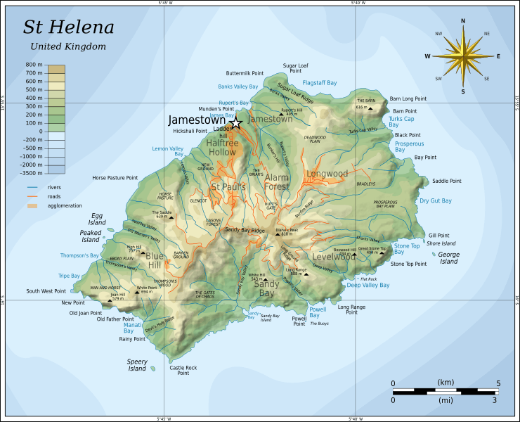
Image: Topographic map of Saint Helena-en

Size of this PNG preview of this SVG file: 740 × 600 pixels. Other resolution: 296 × 240 pixels.
Original image (SVG file, nominally 802 × 650 pixels, file size: 583 KB)
Description: Topographic map of the British island of Saint Helena.
Title: Topographic map of Saint Helena-en
Credit: Self-made in Inkscape. Based on several sources: CGIAR-CSI SRTM 90m DEM Digital Elevation database SRTM30_PLUS bathymetry by Scripps Institution of Oceanography Topographic map of Saint Helena by Barry Weaver and Jean-Pierre Langer Saint Helena Island, a photograph by NASA Earth Observatory
Author: Oona Räisänen (Mysid)
Usage Terms: Creative Commons Attribution-Share Alike 3.0
License: CC BY-SA 3.0
License Link: http://creativecommons.org/licenses/by-sa/3.0
Attribution Required?: Yes
Image usage
The following 3 pages link to this image:

All content from Kiddle encyclopedia articles (including the article images and facts) can be freely used under Attribution-ShareAlike license, unless stated otherwise.