
Image: Torrens catchment map

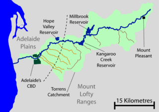
Description: Self created map of the River Torrens catchment and major creeks. Data is from Surface Water Group (June 2003). Report DWLBC 20003/24, Surface Water Assessment of the Upper River Torrens Catchment (Figure 16). Adelaide: The Department of Water, Land and Biodiversity Conservation. Smith, Derek L.; Twidale C.R. (1987). An Historical account of flooding and related events in the torrens river system from first settlement to 1986, volume 1, 1836-1899, Adelaide: The engineering and water supply department. Originally uploaded by me to en:wikipedia then moved here
Title: Torrens catchment map
Credit: No machine-readable source provided. Own work assumed (based on copyright claims).
Author: No machine-readable author provided. Peripitus assumed (based on copyright claims).
Usage Terms: Creative Commons Attribution-Share Alike 3.0
License: CC-BY-SA-3.0
License Link: http://creativecommons.org/licenses/by-sa/3.0/
Attribution Required?: Yes
Image usage
The following page links to this image:
