
Image: Turbina,Calambajd1260 11

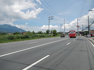
Description: Barangay Turbina [1] Coordinates: 14°11'16"N 121°8'21"E Bus Terminal (Prinza, Calamba City[2] - Pan-Philippine Highway[3]- The Pan-Philippine Highway, also known as the Maharlika "Nobility/Free People" Highway AH26 AH26 is a 3,517 km 2,185 mi network of roads, bridges, and ferry services that connect the islands of Luzon, Samar, Leyte, and Mindanao in the Philippines, serving as the country's principal transport backbone.[4] Maharlika Highway Daang Maharlika) - accessible if entered Exit 50 or Batangas Exit of SLEX. It passes through barangays Turbina, Tulo, and Makiling in Laguna, and continues through Batangas and ends at Lipa City. Along Maharlika Highway are numerous factories, warehouses, and other industrial sites that can be found in Calamba City, Laguna, and Sto. Tomas, Batangas). Mount Makiling [5] --- Turbina Bus Terminal (Prinza, Calamba City)[6] Coordinates: 14°11'4"N 121°8'8"E [7] near SLEX - Calamba (Turbina) Exit[Coordinates: 14°11'34"N 121°8'27"E] Calamba City[8] Calamba, Laguna. (I decided to re-photograph this scenic center of bus transportation, for it is the gateway and only path to Bicol province and other provinces, and the Mountain is blue and clear amid the so bright sun.)
Title: Turbina,Calambajd1260 11
Credit: Own work
Author: Ramon FVelasquez
Usage Terms: Creative Commons Attribution-Share Alike 3.0
License: CC BY-SA 3.0
License Link: http://creativecommons.org/licenses/by-sa/3.0
Attribution Required?: Yes
Image usage
There are no pages that link to this image.
