
Image: UN Palestine Partition Versions 1947

Size of this preview: 289 × 599 pixels. Other resolutions: 116 × 240 pixels | 1,370 × 2,838 pixels.
Original image (1,370 × 2,838 pixels, file size: 1.46 MB, MIME type: image/jpeg)
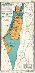
Description: Map of UN Partition Plan for Palestine, adopted 29 Nov 1947, with boundary of previous UNSCOP partition plan added in green.
Title: UN Palestine Partition Versions 1947
Credit: m0103_1b.gif on PLAN OF PARTITION is from UNGA Resolution 181 (27 Nov 1947). Overdrawn UNSCOP boundary is from United Nations Special Committee on Palestine, Report to the General Assembly, 3 Sep 1947, Volume II, A/364, Add. 1.
Author: Zero0000A/RES/181(II)
Usage Terms: Public domain
License: Public domain
Attribution Required?: No
Image usage
The following 2 pages link to this image:

All content from Kiddle encyclopedia articles (including the article images and facts) can be freely used under Attribution-ShareAlike license, unless stated otherwise.