
Image: USA Hawaii relief location map

Size of this PNG preview of this SVG file: 800 × 519 pixels. Other resolution: 320 × 208 pixels.
Original image (SVG file, nominally 1,441 × 935 pixels, file size: 317 KB)
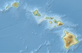
Description: Location map of Hawaii, USA
Title: USA Hawaii relief location map
Credit: own work, using United States National Imagery and Mapping Agency data U.S. Geological Survey (USGS) data SRTM30 v.2 data NGDC ETOPO2v2 data
Author: NordNordWest
Usage Terms: Creative Commons Attribution-Share Alike 3.0 de
License: CC BY-SA 3.0 de
License Link: https://creativecommons.org/licenses/by-sa/3.0/de/deed.en
Attribution Required?: Yes
Image usage
The following 45 pages link to this image:
- Diamond Head, Hawaii
- Green Lake (Hawaii)
- Halalii Lake
- Haleakalā
- Halulu Lake
- Hanapēpē River
- Honolulu Volcanics
- Hualālai
- Hā'upu
- Ka Loko Reservoir
- Kalapana, Hawaii
- Kamakou
- Kauhakō Crater
- Kawaikini
- Kaʻala
- Kaʻau Crater
- Kealia Pond National Wildlife Refuge
- Keanapuka Mountain
- Kilauea
- Kilauea Light
- Kohala
- Kohala (mountain)
- Koko Crater
- Koʻolau Range
- Kāohikaipu
- Kōnāhuanui
- Kōʻula River
- Lake Waiau
- Makapuu Point Light
- Makauwahi Cave
- Mauna Loa
- Mount Waialeale
- Māhukona
- Mānana
- Nuʻuanu Pali
- Olokui
- Olomana (mountain)
- Palolo, Hawaii
- Puʻu Kukui
- Puʻuwai, Hawaii
- Subaru Telescope
- Ulupaʻu Crater
- Violet Lake
- Waiʻanae Range
- West Maui Mountains

All content from Kiddle encyclopedia articles (including the article images and facts) can be freely used under Attribution-ShareAlike license, unless stated otherwise.