
Image: US insular areas C

Size of this preview: 800 × 337 pixels. Other resolutions: 320 × 135 pixels | 1,482 × 624 pixels.
Original image (1,482 × 624 pixels, file size: 49 KB, MIME type: image/png)
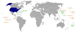
Description: A map of US territories, color coded depending on whether or not. The fifty states and DC are colored blue, inhabited territories are colored green, and uninhabited territories are colored red.
Title: US insular areas C
Credit: File:US insular areas.png
Author: User:Hoshie
Usage Terms: Creative Commons Attribution-Share Alike 3.0
License: CC BY-SA 3.0
License Link: http://creativecommons.org/licenses/by-sa/3.0
Attribution Required?: Yes
Image usage
The following page links to this image:

All content from Kiddle encyclopedia articles (including the article images and facts) can be freely used under Attribution-ShareAlike license, unless stated otherwise.