
Image: US pennsylvanian general USGS
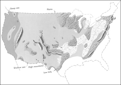
Description: Generalized geographic map of the United States location in Middle Pennsylvanian time. During the Carboniferous period, the contrast in the distribution of land and water from the ancient past to the present becomes more dramatic. The map shows the outline of the United States as it looked during the Pennsylvanian Period some 300 million years ago. It gives the appearance of reversing present-day geography. A highland which lay to the east, south, and north supplied much of the sedimentary debris that was spread over the midwestern part of the United States. The Midwest was mainly a low swampy area in which scouring rushes and fern trees grew in profusion. Sediment was carried into the region from deltas to the east. From time to time, the level of the sea fluctuated -- possibly because of glacial conditions in the Southern Hemisphere. Swamps were flooded, and forests were destroyed. Slowly, layers rich in tree stumps, spores, branches, and leaves were deposited. Later, heat and pressure changed these layers into the coal beds that are so extensive in Illinois, Kentucky, Pennsylvania, West Virginia, and Tennessee. To the west, marine limestones, sandstones, and shales accumulated in shallow seas whose vast expanses were dotted with shoals and islands. Some of the very large islands were formed by the buckling and uplifting of parts of the Earth's crust.
Title: US pennsylvanian general USGS
Credit: http://pubs.usgs.gov/gip/continents/pennmap.jpg
Usage Terms: Public domain
License: Public domain
Attribution Required?: No
Image usage
The following page links to this image:
